Shop
Showing 181–195 of 734 resultsSorted by latest
-
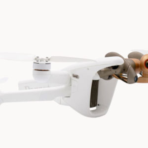
BATTERIES, CONSUMER, DJI PHANTOM 4 Accessories
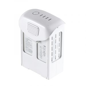
DJI Phantom 4 Pro – Spare Battery (5870mAh, High Capacity)
 BATTERIES, CONSUMER, DJI PHANTOM 4 Accessories
DJI Phantom 4 Pro – Spare Battery (5870mAh, High Capacity)
Max 30 mins flight time.
Professional aerial imaging benefits from longer flight times. The Phantom 4 Pro has a maximum flight time of 30 minutes, providing more time in the air to capture the perfect shot. The DJI GO app shows battery lifetime and calculates remaining flight times according to distance traveled and more. It will give alerts when it reaches a minimum safe amount required for a safe journey back to the takeoff point. An advanced battery management system is also in place to prevent overcharging and over draining. When placed in longer term storage, batteries will discharge power to maintain good health.SKU: n/a -
BATTERIES, CONSUMER, DJI MAVIC Accessories
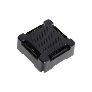
DJI Mavic – Battery Charging Hub
Charge four batteries together.The Mavic Intelligent Flight Battery Charging Hub is designed for use with the Mavic Intelligent Flight Battery. When used with the Mavic Battery Charger, it can charge up to four Intelligent Flight Batteries. The Intelligent Flight Batteries will be charged in sequence according to their power levels, from high to low.
The advanced Charging Hub optimizes charging to improve efficiency. The advanced version charges fully in one hour less than the standard version. When used together with a Phantom 4 charger, the charging time is reduced to 2.5 hours.SKU: n/a -
BATTERIES, CONSUMER, DJI MAVIC Accessories
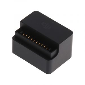
DJI Mavic – Battery to Power Bank Adaptor
Use the Mavic battery as a power pack.The Mavic Battery to Power Bank Adaptor is designed to provide power from the Mavic Intelligent Flight Battery to mobile devices such as smart phones or tablets. Use the Mavic battery as a power pack.
SKU: n/a -
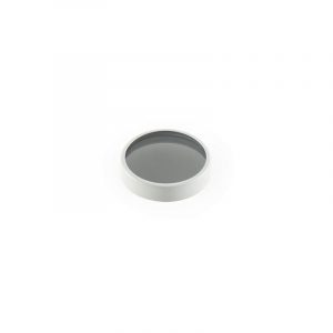
CONSUMER, DJI PHANTOM 4 Accessories
DJI Phantom 4 – ND4 Filter
Specifically made for the DJI Phantom 4, this ND4 filter reduces the amount of light coming into the sensor. It gives you the freedom to create your own work by allowing more control of the camera’s aperture, exposure time and sensor sensitivity settings.
SKU: n/a -
-
PARROT PROFESSIONAL
Parrot ANAFI Ai Drone
Key Features- Fly Farther with Dual-Band Wi-Fi/4G LTE
- Ideal for Photogrammetry, Filming & More
- Up to 4K/60 & 4K HDR10/30 Recording
- Twin Sensor Obstacle Avoidance System
- 0.46 cm/px GSD at 100′ Mapping Accuracy
- Up to 6x Lossless Zoom
- 14 EV Dynamic Range
- 6 Different Camera Modes
- 5 Autonomous Flight Modes
- Skycontroller 4 Remote Control Included
SKU: n/a -
SOFTWARE, UgCS
UgCS Enterprise
Live Video Feed Features
All the features and benefits of UgCS Pro.
Benefit from a live video stream from UgCS for DJI to UgCS
(currently compatible only with Win & Android)- Multiple SDK connections
- ADS-B Transponder
- Compatible with UgCS Mapper to perform live video mapping.
SKU: n/a -
SOFTWARE, UgCS
UgCS Expert LIDAR Toolset
The UgCS LIDAR toolset unlocks the full potential of LIDARs enabling effective remote sensing without human error. Delivers everything that UgCS Pro delivers plus LIDAR capabilities.
- Save time on mission planning with flight patterns and turns designed specifically for LIDAR surveys
- Acquire high-quality laser data with preset IMU initialization patterns and anti-shake LIDAR turns
- High accuracy of acquired data ensures getting desired results with one trip to the field
Supports most popular LIDAR platforms: DJI, YellowScan, Riegl, PhoenixLIDAR, LIDAR USA, GeoCue, Rock Robotics, & GeoSun LIDAR
SKU: n/a -
SOFTWARE, UgCS
UgCS Mapper
Create Maps offline with UAV Drone Photogrammetry
Mapper is a lightweight software tool for making 2D maps and elevation out of drone imagery and video – purely offline.
Increase surveying productivity – validate the quality of dataset – collected images are suitable for map stitching, before leaving the survey area.
Higher flight safety – create up to date 3D map and elevation data, i.e., when default map sources are not accurate enough for safe mission planning.
SKU: n/a -
SOFTWARE, UgCS
UgCS ATLAS AI
ATLAS Optimses Drone & Satellite Geospatial Data Analysis
ATLAS leverages AI to automate time-consuming manual analysis of UAV & Satellite data, such as object counting, volume measurements, making a true DTM, and much more.
ATLAS contains its own AI-engine, which learns from users activity and automates regular data analysis tasks.
ATLAS can be taught to identify changes of assets, components, and geospatial data over time, to support various monitoring, inspection, and integrity activities.
SKU: n/a -